
A recent project looking at how Michigan’s land was divided and commodified after armed Native resistance in the area was defeated led me to the General Land Office township plat maps (available through Seeking Michigan). These maps were drawn by the original surveyors between c. 1815 and 1860 and contain a truly remarkable look at Michigan's ecological past and wide-spread changes brought about by settlement, agricultural and resource extraction. Some of these maps, especially the later ones, are beautifully drawn, deeply detailed looks at Michigan’s awe-inspiring natural landscape.

Contrast the communal land tenure on the Nottawseepe Reserve with the American Mendon Township and private land division surrounding it.
Surveyors were charged with mapping the division of land through the township and rage system into regular parcels for easy sale in the emerging American market (the taxes to pay down debts accrued during the Revolutionary War). They walked section lines in townships through each county noting the trees and land cover, river flows and harbor points, mineral and soil properties, etc.; all the qualities investors were interested in. Land was rated first, second and third. Swamps were outlined, potential mill sites marked; prime agricultural and lumbering lands were logged.
All later divisions in Michigan's landscape are riffs off of these monumental steps through places soon to be utterly transformed. Every house and every subdivision, all gas lines, strip malls, and coffee shops in the state have in their birthright, written by deed, the lines laid out then. These walks through woods and meanders down rivers would mark the end of the very landscape the men were tasked with surveying. Within a generation the ecosystems these men walked were largely gone as the geography of capitalist accumulation made its demands on the Great Lakes. Demands, apparently, unmet today.
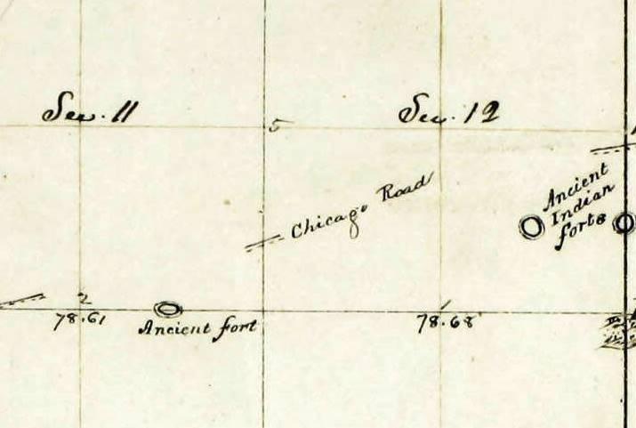
A rare mention of earthworks, south of the Chicago Road (the Old Sauk Trail, now US12) near Bronson, Michigan in Branch County.
On occasion the surveyors noted Native villages, fishing sites, fields and sugar camps, cemeteries and trails. It was clear from looking at the maps that long after treaties had been signed, reservations formed, and violent removals carried out, indigenous people were continuing to live in independent and largely traditional lives in many parts of the state. As surveyors, accuracy in measurement was important, and it was possible to use their notes and see how those two hundred year old locations fit in the landscape today. A time consuming side-project was begun.
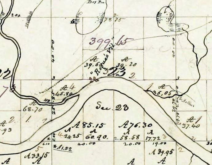
Rouge’s Village and trails on the Grand River in Section 23 of Kent County’s Plainfield Township.
Dozens of hours spent looking at nearly 1900 maps culled around 160 locations that could be found with some precision in today’s Michigan. This Google Map is surely just a hint of the actual number and variety of Native sites during that period and there are some big caveats about the quality and quantity of the information. However, it is a small window into the largely unwritten past and gives a sense of where and how Indian people were living in Michigan around the period of statehood in 1837.

The Wyandot Reserve (above) on the Huron River near Flat Rock above, was the last reserve in southeast Michigan. The band, including a son of Blue Jacket, was removed to Kansas in 1842 and the land sold at auction. I have superimposed the area, now Oakwoods Metropark, over the survey map done when planning the removal. It is possible to say exactly where each family homestead - the irregular shapes - sits in the present landscape. For example, the Nature Center now stands in Katy Quawquaw's orchard.
Some of the villages mentioned, and many unmentioned, continue to be occupied today by the descendants of those whose lives are recorded on these maps. For them and others, Michigan has always been Indian country.
A few caveats and explanations
*Each pin is titled as it appears on the original map (most of the time) and contains a link to the original map and, when possible, the notes from the survey. The pins are themed (i.e. a sugar camp looks like a tree, a village a house, etc.)
*The surveyors were only asked to follow and comment on the section lines that they were dividing townships, meaning that the vast majority of land, and Native sites on that land, was not crossed and noted.
*Almost all of the sites mentioned in the maps were sites in use at the time, each one of these surveys is a snapshot of a day. Many other sites in the landscape used in a different season or activities like fishing spots, gardens and groves and cemeteries might not be noticed.
*Mounds are earthworks were largely invisible to the surveyor’s eye and rarely mentioned though the state was filled them While cemeteries are frequently mentioned, I chose to not locate them on the Google map, even approximately.
*While told to note human constructions, this was not their main task, and some surveyors had more interest than others. Some surveyors were better than others (I have my favorites). Many sites might have been seen, but not recorded.

Sugar camps are the most frequently mentioned sites. This one was among the lakes of Breitung Township in the far western Upper Peninsula.
*The detail of the first surveys in our area of southeast Michigan are often less than rudimentary while in some of the later maps looking at the Upper Peninsula it is extraordinary.
*The maps span forty years with the maps getting more recent as you move north. Those years were of tremendous change .While the maps of the north are more detailed, and where we would expect the Native landscape to be most apparent, many of the Native groups would have left or been forced from the state for Canada, Minnesota, Wisconsin and elsewhere.
*Unlike in 1815, Native groups would not be the only human settlement even if they were still the majority in some areas. As American populations increased the Native footprint on the landscape became less ubiquitous and noticeable.
*Trails are, by far, the most remarked on part of the Indian landscape. However, they are also the least exact and most approximate of sites. To spend the time trying to figure out how segments of trails might fit together was too daunting and time consuming. See Hinsdale’s maps for trails.
*I made every effort, consulting other maps and GIS services to place these pins as close as possible to where they are recorded. Many are within 10 yards or so of being accurate. If I was unsure, I say “approximate”. Reserves are close, but approximate.
*Many more sites may have been recorded in the notes and not on the maps, from which all these sites come. To read them all would take several years and beyond the scope.
*I read over 1800 maps; often late into the night and am sure I missed a few.
That a ton of work - fantastic! The map sorta confirms why my father in law's plough turned up so many arrowheads.
ReplyDeleteAnd those points probably span many thousands of years of occupation and activity and reflect variety of different cultures.
DeleteThat's right. Unfortunately many of his finds were (possibly) stolen from him over the years, but those that remain were analyzed and did cover a huge time span.
DeleteMatt, this is really impressive. Great work.
ReplyDeleteThanks Ben!
DeleteThis is very fascinating to me. With my very limited knowledge of the subject, it seems to me that many of the Native villages never went into private ownership and more likely became some sort of public land whether a park, civic center, library, or school.
ReplyDelete